


Connecting Disjointed Parts of Richmond, A Series
Welcome to What’s Next, Richmond (WNR). In this series we will highlight connections between parts of the City that are physically close together, but difficult to travel between in practice.

In today’s story we will be talking about bike lanes, and specifically a bike lane that merges into mixed traffic. Though the car-bike collision that has put Mary Munford Principal Mr. Muzik in the hospital this week did not occur in these specific bike lanes, I’d like to mention how saddened I am as both an RPS teacher as well as a bicyclist on the streets of Richmond to hear about what has happened. We hope for both the health and recovery of Mr. Muzik, and a renewed commitment to making our city safer for all users of our streets and sidewalks.
Each week in this series we will talk about a new intersection or part of the city that feels disjointed despite being physically close to nearby points of interest. Typical themes that relate each of these locations are ways in which infrastructure and street design either contributes to or catalyzes the sense of isolation. Most locations are on the City of Richmond High Injury Network, a system streets in the City that have seen disproportionately high instances of injury or deaths caused by cars.
In our first installment of the series we will look at the intersection between Brook Road and Chamberlayne Avenue. We will examine what makes this part of the city disconnected, look at solutions already in the pipeline, and make a case for quick-build solutions that could bring relief and connection on a faster time scale.
(Re)Connecting Downtown and the Northside
Traveling from the Northside towards Downtown by bike along Brook Road is generally characterized by buffered and parking protected bike lanes. This comfortable setting for bikers meets an abrupt end just before the bridge over I-64/95, where bikers have to merge into mixed traffic at the same location where cars are exiting the interstate highway.
Brook Road Bike Lane Approaching Downtown:
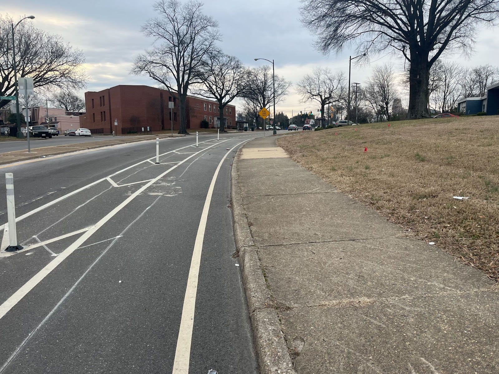
Mixed Traffic Bike Merge where Brook Road Meets Chamberlayne Avenue:

The result of this comparatively hostile environment for biking is that many vulnerable riders (elderly, young, inexperienced, traveling with children) are likely to avoid this route. Though the next bike lane picks up a few blocks over on 1st Street, traveling in the same space as cars that are exiting an interstate highway feels like an unacceptable connection to most bike riders.
The same problem exists for pedestrians trying to make the trek into the Southern part of Jackson Ward or Downtown from areas like Gilpin Court. Any prospective pedestrian has to walk across 120 feet of fading crosswalk without any pedestrian signal or refuge island. Three of the four lanes of traffic that make up this crossing are cars exiting from the interstate highway.

Upcoming Solutions
Needless to say, it can be intimidating to traverse this section of the city. The way that the interstate highway splits this section of the city is the product of major historical wrongs in terms of segregation, racial bias, and community separation. There are efforts in play in the city that are aiming to correct some of historical faults, such as the Reconnect Jackson Ward project, which aims to build a highway-top park over the interstate to re-join the historically black Jackson Ward neighborhood that was split in half by I-95. That being said, a major project that is highly dependent on federal grant funding doesn’t seem likely to be completed in the near-term, especially in the current political climate.
The Fall Line Trail will also provide a connection through this part of the city that will create a safer path for both pedestrians and bikers. In fact, two of the City’s disjointed protected bike networks (Brook-Brookland Parkway- School) and (1st Street-Franklin Street, etc) will be linked by the Fall Line Trail.

The problem with relying on the Fall Line Trail’s completion to address this connectivity problem is that the trail is many years away from completion, as we discussed in a previous article. This major connection between two parts of the City was identified as a “Super Need” for the City by the Richmond Connects Near-Term Action Plan, and yet the only two solutions to address this are up to a decade away from implementation.


A Faster, Less Permanent Solution
A timely solution to this connection problem may lie in the Richmond Office of Equitable Transit and Mobility, which is in charge of a Richmond Connects process called “Lighter, Quicker, Cheaper” (LQC).
As described on the LQC webpage:
Lighter, Quicker, Cheaper (LQC) is the first phase of the Richmond Connects implementation process. Recognizing that permanent infrastructure and street design changes take a decent amount of time and money, LQC aims to meet the needs raised by Richmonders in a timely manner. The methods used may include things like street art, temporary road closures, and signage. LQC does not aim to replace permanent infrastructure changes in the long term, rather its goal it to improve safety and accessibility in the interim before permanent changes can be made.
While we wait for the permanent improvements provided by Reconnect Jackson Ward and the Fall Line Trail, there could be LQC solutions such as closing off one of the car travel lanes using delineator cones and planter boxes to be designated as a shared-use path. Here’s an example of a similar quick-build solution for a shared-use path in Andover, MA:

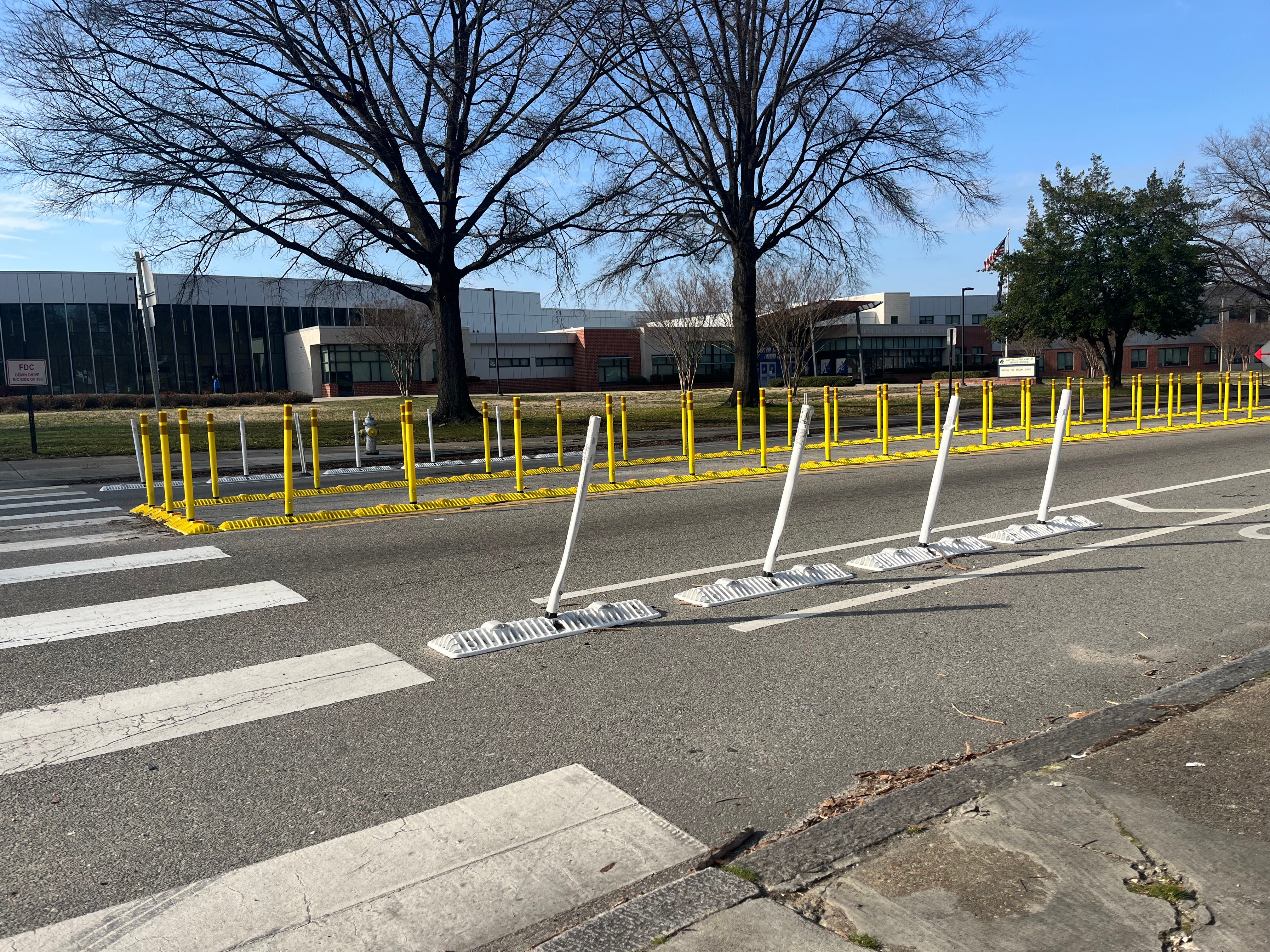
There are more semi-permanent solutions than traffic cones that would increase the feeling of safety. One example of this are the barriers used on Mosby Street as a part of the Lighter, Quicker, Cheaper School Safety project.
By using Lighter, Quicker, Cheaper solutions, Richmonders could start reaping the benefits of a better connected Jackson Ward (and Northside in general) years ahead of the current schedule. Getting an LQC solution to this problem would, of course, require enough members of the public advocating for the idea.
It may seem extreme to suggest closing a travel lane for cars in order to accommodate non-car drivers. It’s worth noting that closing lanes is a relatively common practice in the City, it’s just a question of who gets to benefit from it.

Thanks for reading!
If you’d like to suggest another disjointed part of the City for the series, feel free to reach out or
The city should require builders or take responsibility itself to provide a secure walkway around construction sites. Instead, pedestrians are often forced to take a much longer route, crossing streets or going an extra block. Many people won’t see the longer trip as worth it and end up trying to squeeze by in unsafe conditions.