


A Skybridge Deferred: The Limitations of the Proposed Arthur Ashe Bridge
Welcome to What’s Next, Richmond (WNR). This week we dive into the recently released plans for the Arthur Ashe Bridge Project in the context of several other transportation improvements in the region.

The Richmond 300 Master Plan, a comprehensive City plan that seeks to create “a more equitable, sustainable, and beautiful future for all Richmonders,” specifies a network of improved transportation routes through the City. Many of these proposals, including new bike networks, enhanced transit corridors, and “Great Streets” are summarized in the Richmond 300 Future Connections Map.
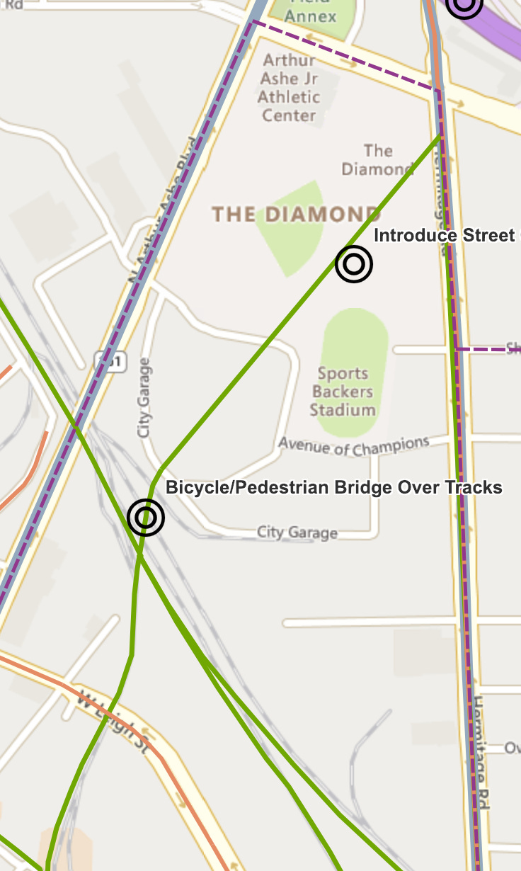
One element of these future connections that caught the eye of many Richmonders is a pedestrian/ bicycle skybridge that would connect the bottom of the under-construction Diamond District to a network of future shared-use paths (in green) spanning all over the City.
Beyond capturing the imagination of Richmonders, the skybridge promised to serve as a major connection point for walkers and bicyclists who want to be able to travel through the City on paths that are not directly adjacent to existing roadways.
At the March 14th “Richmond Bizsense Future of the Diamond District” event, City Council member Katheryn Jordan shared that the City will not be pursuing the skybridge idea. Due to land acquisition issues, cost, CSX height requirements, and several other variables, the City will instead allow the nearby Arthur Ashe Boulevard Bridge to serve as the connection point over the CSX railroad tracks for bicyclists and pedestrians, according to Jordan.
On June 2nd, the City of Richmond released the first renderings for the Arthur Ashe Bridge Project, a plan to replace the aging Arthur Ashe bridge with added space for pedestrians and bicyclists.
This week we will dive into these plans to consider how they fit into the transportation ecosystem around the bridge, and assess how well the future bridge will serve as a replacement for the skybridge connector concept for pedestrians and bicyclists.
Why Does It Matter, Anyways?
A brief case for the ways in which a vibrant car-free transportation system is beneficial to the whole City- even car drivers.
The idea of a pedestrian bridge over the CSX railway tracks into the Diamond District certainly was partially alluring simply because it would have been really cool to look at. The BP Pedestrian Bridge in Chicago’s Millennium Park comes to mind in comparison.

The benefits of an effective non-car transportation system, however, go far beyond the novelty factor.
A 2021 Academic Journal Review provides evidence for many of the individual and public health benefits of bicycling, including personal health and fitness, as well as mental health benefits and reduced pollution and carbon emissions. By building a more inviting and connected bicycle system, the City is investing in a happier, healthier, and greener society.
Another major benefit stems from the fact that a bicycle is much smaller and lighter than a car. This obvious fact has major implications for how bicycle travel helps mitigate motor vehicle congestion. Each person who chooses voluntarily to ride a bicycle instead of driving reduces the number of cars on the road (or in your way on your commute). Bicycles, in turn, require much less public space to move the same number of people because of their relatively smaller size.
This is best demonstrated by a 1991 image from the City of Munster:

A 2015 Study in Copenhagen demonstrates that traveling by bicycle is also six times cheaper for society than traveling by car. This is due to the reduced wear that the relatively lighter bicycles apply to the roadways, but also considers the impact of other externalities such as effects on pollution and public health.
In these ways, building a vibrant bicycle network in a city serves to reduce traffic congestion for cars at a relatively low comparative cost, and the planned skybridge would have provided significant connectivity to bolster the bicycle network in the City.
Does the Proposed Arthur Ashe Bridge Really Serve the Same Role as the Skybridge?
Comparing the bridge’s bicycle and pedestrian capacity to the planned routes before and after the bridge to assess if it will truly serve the same active transportation catalyst promised by the skybridge concept.
The current Arthur Ashe Bridge leaves a lot to be desired in terms of pedestrian and bicycle accessibility.

By comparison, the proposed replacement bridge features a shared use path on the west side of the bridge and a widened sidewalk on the east side. The proposal also includes planter boxes and benches to separate the pedestrian sections from the car sections of the bridge.
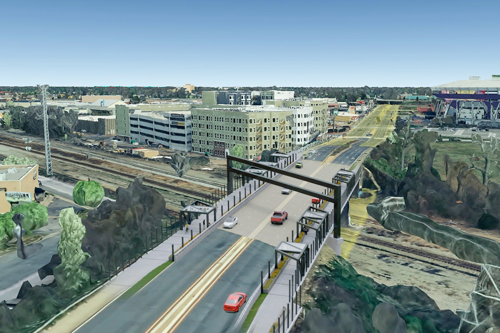
The shared use path on the west (southbound) side of the bridge will tie into a protected bike lane and widened sidewalk that is a part of the Diamond District project. These bike lanes will be “implemented in conjunction with the Arthur Ashe Boulevard Bridge replacement project” according to the latest Richmond City Budget (Section 8-85).

The sidewalk and protected bike lanes leading to the bridge will both be ten feet wide with a two foot buffer in between the two. On the bridge these two separated systems will converge into a single ten foot shared use path. Note that this is over a 50% reduction in total designated space for pedestrians and bicyclists. Imagine the bottleneck that would be created if the four car lanes on the Boulevard similarly converged into a two lane bridge.
There will not be the same funnel effect on the east side of the bridge, where the sidewalk north of the bridge and sidewalk on the bridge nearly the same size. Recall, however, that councilmember Jordan said in March that the Arthur Ashe Bridge Replacement will meet the same needs as the skybridge that will no longer be constructed.
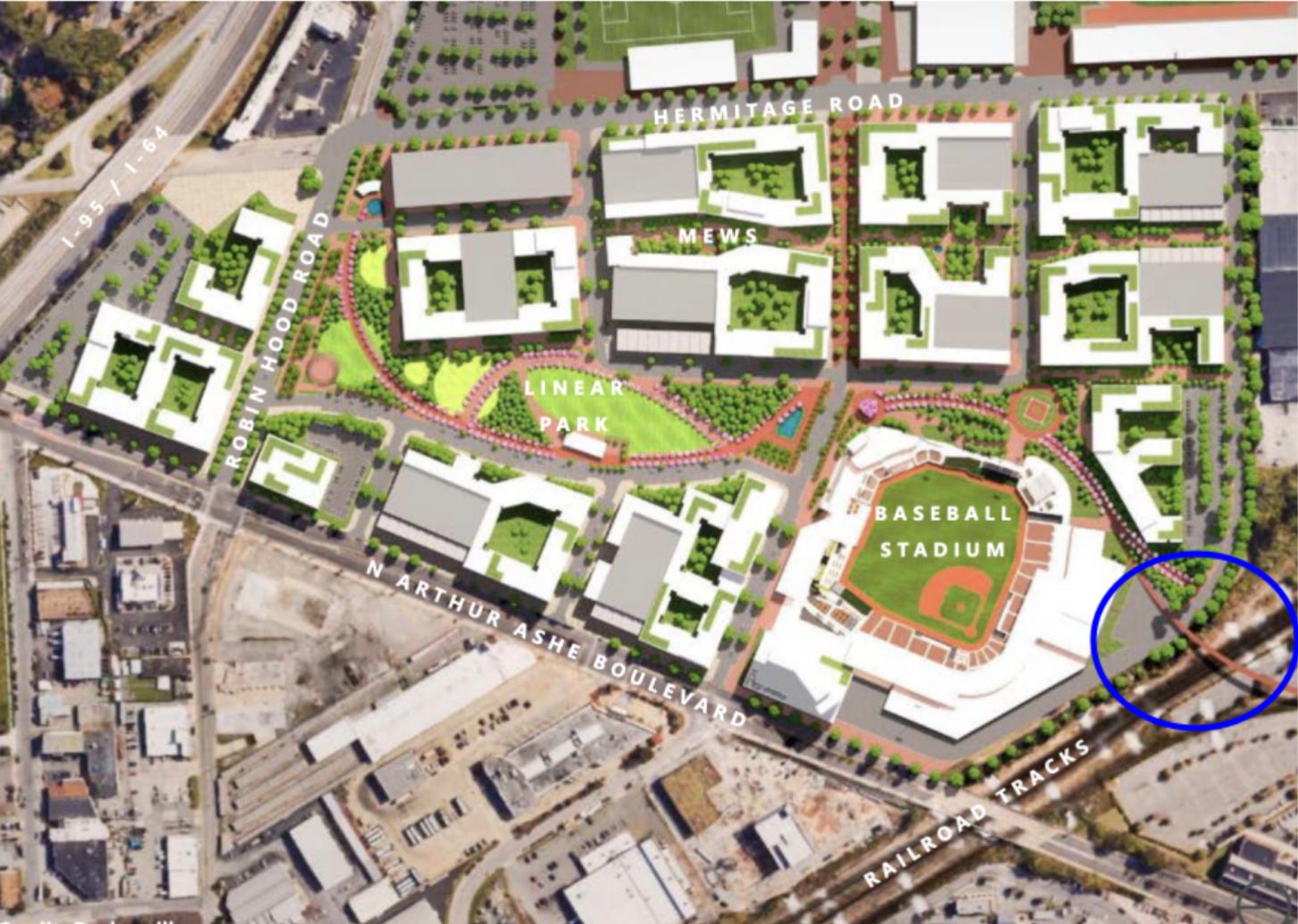
The skybridge would have provided a connection for travelers using the planned central path through the Diamond District. Beyond creating a path to nowhere (see the bottom right corner of the above rendering), deleting the skybridge creates a greater need for space on the east side of the Arthur Ashe Bridge. Major connections include the future Science Museum Shared Use Path, as well as shared use paths along the rail right-of-way that connect to destinations from Scott's Addition to Shockoe Bottom (specified in the Richmond Connects Strategic Plan). All of these paths are planned to converge near the original landing point of the skybridge.
The current eight foot sidewalk planned for the east side of proposed Arthur Ashe Bridge replacement does not match the service potential of the skybridge plan. When you couple this with the fact that the shared use path on the west side of the bridge is already half the size of the planned path leading into it, it begins to feel like the replacement bridge will be obsolete within years of its completion. It would be great to see a commitment to pedestrian and bicycle infrastructure that at least mirrors the size of the lanes leading into the bridge, and a full-size pedestrian and bicycle section on both sides of the bridge would go even further to help prepare for the scale of pedestrian and bicycle investment indicated by the Richmond 300 Master Plan.
Bridges are a long-term investment. Recall that the current Arthur Ashe bridge has lasted over 75 years. Though the Arthur Ashe Bridge Project is a major improvement over the current bridge in terms of pedestrian and bicycle accessibility, the current design seems insufficient considering the scope of the medium term plans for our City, let alone the next 75 years.
Thanks for reading! If you haven’t yet, make sure to complete the survey for the Arthur Ashe Boulevard Bridge project, which will be open until June 22nd.
As always, don’t forget to